Silk Road Mountain Race - Day 4 • Arabel Plateau to Big Malyy Naryn River Bend
Silk Road Mountain Race - Day 4
August 15, 2023
Arabel Plateau to Big Malyy Naryn River Bend - 92 Miles
Start 6:35 AM Finish 10:23 PM
Total Duration 15:46
Moving Time 12:41
Stopped Time 3:06
Ascent 4,666’
Descent 8,580’
Slept at 9,266' elevation (tent)
Race Total 393 Miles
Details at: https://ridewithgps.com/trips/131493897
I ended up sleeping well on Arabel Plateau at 12,160' elevation. It had been cold last night, and my thighs were shivering as I was trying to fall asleep. Enveloped inside my sleeping bag and silk liner I was wearing wool socks, down socks, merino wool leggings, a heavy merino wool top, and a hooded goose down jacket. I finally couldn't take the shivering and donned my rain pants overtop the leggings. It barely tide me over, and I managed to stay warm enough for the rest of the night. I slept with my devices inside my sleeping bag to prevent battery loss in the cold.
I woke with the morning light and my water bottles were frozen. My tent was covered with frost and a thin layer of ice from my breath. It took me an hour to pack. I have little manual dexterity when I'm wearing long finger gloves, and dismantling my tent had to be done bare-handed. The ice and bitter cold stung my fingers. My ice and frost covered fly was too bulky, and had to be packed separately. I rolled it up in my cloth food bag and carefully strapped it to my rear rack.
Despite the bright sun, the air was brisk. I started off in my bib, leg-warmers, rain pants, jersey, winter under-layer, merino wool under-layer, gilet, jacket, down jacket, and long-finger gloves. My toes were cold, but I elected not to don my shoe covers. There was no clear path across the dirt and grass clumps to the mining road, and my shadow was long.
My goal today was to make it Naryn, where I'd be able to sleep in a guesthouse and get a decent meal. I had no idea what the descent from the plateau would entail, but it would ostensibly be mostly downhill to Naryn. I'd been warned that Naryn was known as 'Scratch City'. After brutal Jukku Pass, racers might be tempted to call it quits. To make it to the finish by midnight on August twenty-sixth I needed to ride seventy three miles a day. I'd ridden three hundred miles the first three days, and was ninety miles ahead of where I needed to be.
There was no discernible track and I used my GPS to navigate to the gravel mining road, which I could see in the distance. I crossed a bridge across a raging stream. Thank goodness the bridge was out here in the middle of nowhere. It barely seemed wide enough or substantial enough to carry a motor vehicle. I would not have wanted to have waded across the frigid current.
The mining road had clearly been scraped with a giant bulldozer and there was a drop-off from the surrounding terrain. I had to lift my bike several feet down to the gravel. In the distance I noticed a teal colored container with a small window. I later learned that it was a refuge with bedding. Other racers had slept there.
It was great to be back on a road, and it was the smoothest surface I'd been on since beginning my climb up Jukuu. Navigation atop the plateau was finally straightforward. Steel constructed utility poles were spaced alongside the road which I imagined were erected by the Soviets. Rising from concrete footers atop earthen mounds, they were built to endure the harsh weather conditions.
It was a bright crisp morning without a single cloud in the cobalt blue sky. I felt like I was at the top of the world. I've summited passes this high and have ridden above 13,000' in Mexico, but didn't recall sleeping at or riding distance at this elevation. The surrounding landscape was barren with dirt, rocks, and clumps of dirt. Singular yurts could be seen on the horizon. There was very little motor traffic.
After I had warmed up I stopped on the side of the road at a giant boulder where I could lean my bike and strip down. I removed my rain pants, long sleeve merino wool top, winter under layer, down jacket, and long finger gloves. As I was changing, a large flock of sheep came approached and enveloped me. A herdsman appeared on horseback, and we tried to communicate. He asked if I spoke Russian and I replied English. He wanted to know if I had slept on the plateau and I pointed to the where I'd been. I asked him if he had seen other racers ahead of me and he replied four.
Occasional motor vehicles passed on the gravel road. After five miles I crossed a stream that ran through culverts underneath. After a few more miles I crossed another stream with an expansive gravel bed. At 8 AM and after nine miles of riding, I came to the intersection with gravel M-048. From here I continued straight on double track. It meandered and the course was difficult to navigate. My GPS kept beeping that I was off-course. I later realized that I had veered astray and then returned to the course. I passed a baby blue steel container that was someone's domicile. Alongside it was a pen full of goats. I then rode by Arabel Lake. I'd been steadily climbing and had reached 12,600' elevation.
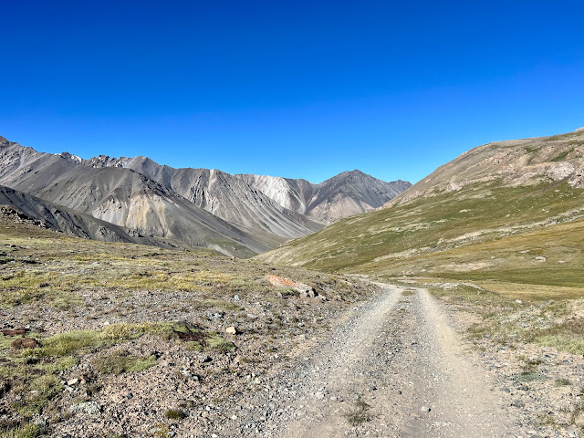
By 9 AM I'd ridden fifteen miles across the plateau and had reached the descent. Unlike yesterday's treacherous climb there were no landslide areas, and I was able to ride the switchbacks down into the valley. I was above the tree-line and the surrounding ridges were barren. Olive colored grass grew to either side of the emerging Arabel'su River. My right index finger was sore from the iPhone Quad Lock mount on my handlebars. Unlatching my iPhone had become challenging and it was difficult to take photos.
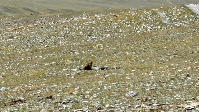
There was a tremendous headwind, similar to the descent on the second day. Air was rushing up into the mountains as the lowlands heated up. The river was to my left. After the switchbacks I rode a double track through expansive grasslands. It was mostly flat with a slight descent down stream. Occasionally the course would cut up through the valley wall and then descend back down to the river. Feeder streams flowed from the plateau above and needed to be crossed. Some of them had wide beds of gravel with numerous channels of running water. At 11 AM I passed Oscar, and shortly thereafter I overtook Sam. The headwind continued to be ruthless. The grass was now littered with rocks, and I spied another marmot.
At 12:20 PM the course cut away from the river towards a valley from a branching stream. I crossed a janky wooden bridge over the flowing turquoise tributary and was at the base of a ginormous valley wall. A small house and corral stood near the bridge. I noticed solar panels on the roof and a satellite dish out front. A donkey was standing in the front yard. I then passed another small structure and yurt. The course cut back to the stream that I'd been following which was now the Burkhan River.
At one of the stream crossings I stopped to filter water. I was always judicious about where I did this, and tried to avoid areas where livestock had grazed. Cattle and horses were everywhere in Kyrgyzstan. The water was frigid and it hurt my fingers to squeeze the filter bag. Because of all the sediment I need to apply great pressure. I crossed paths with two bike-packers heading up to the plateau, and asked how many racers were ahead of me. They replied five. I wished them good luck with the pass. They smiled and replied that they had a tailwind.
At 1 PM I passed Sam and Oscar having lunch by the side of the road. They had slept up on the plateau, and didn’t think it was possible to make it to Naryn today because of the wind. They asked me if I had enough food. I had finished all my Azovskaya Kozinak bars and was now consuming Snickers. I passed two more bikepackers, both female, who were headed up to Arabel. The wind was still ferocious.
At 3 PM the course cut away from the river and climbed up out of the valley. I climbed up over a ridge and then down towards an adjoining stream. Thirty minutes later I crossed the Dzhylusu River on a steel girder bridge. The frothing blue stream had cut a gorge through the rock. Across the valley I spied M-059, which I would eventually join. I had ridden fifty five miles and took a left. I had hoped that this would be a direct smooth route to Naryn, but the rocky dirt surface on M-059 was just as shoddy as what I'd just been on. There were marmot tunnel entrances in the middle of the road just like the prairie dog holes I'd seen on the Great Divide. Why do they burrow in the middle of the road? I was on a gradual descent and passed two more bike-packers heading up towards the pass. The confluence of the two rivers I'd been following had now become the Bolgart River
At 4:50PM I passed Quentin (cap 89) from Belgium. I was still following the the Bolgart River and came to the Archaly River fork on the opposite side. A half hour later I saw a bridge crossing ahead and knew from my GPS that I'd be crossing it. I had hoped that I'd be staying on M-059 straight to Naryn and was disappointed. There were a few small buildings on the other side and I leaned my bike against one to change my layering and eat a Snickers bar. Quentin was gaining on me from behind. Suddenly a man walked out of the structure and I realized it was an outhouse. It was awkward.
The course then began a steep single-track hike-a-bike up a grassy hill. At this point it was clear that I wouldn't be reaching Naryn tonight. After the climb I rode down into a beautiful valley and came to a bridge crossing. I stopped on the bridge deck and leaned my bike against the rail. I had run out of water and went down to the stream to filter more. Quentin caught up with me and followed suit. On the other side of the stream I climbed up over a ridge and then back down to the stream. I was now following the Dzhinalach River, and it was starting to get dark.
I had another climb and then enjoyed a beautiful descent into a wide open valley. The course took me through a wheat field. It was confusing and I double checked my GPS. A twelve inch path had been cut through the green stalks by racers. It was dark and there were irrigation ditches which made it difficult to ride. At the far end of the field I came to a gate with a road on the other side. A motor vehicle approached with it's headlights, and I felt conspicuous exiting through the gate. I later heard that the farmer was furious that a hundred racers had bushwhacked through his crops.
It was 8:24 PM and I joined up with gravel M-068 alongside the Malyi Naryn River. I rode through the small village of Tamdy-Suu where lights were strung along the road. I then came to Örük-Tam. Using Chris’s advice, I approached two children on the road and questioned, "magazin, Coca-Cola, Snickers?". They pointed to a building. There were no signs and I went to the wrong house. I asked the children again, and was correctly directed to a place where I could get something to eat and drink. I hadn't eaten a proper breakfast, lunch, or dinner.
There were two bikes parked in front of the building. Andrei, (cap 11) from Russia, and Dmitiri, (cap 29) from Kyrgyzstan, were inside trying to convince the proprietors to let them spend the night. I communicated by pointing to items that I wanted, and the prices were shown to me on a calculator.
I purchased two large ice teas and two bags of chips, and then sat out front on a step. One of the bags contained chips as hard as stones and I was afraid that I'd break a tooth. Andrei and Dmitiri had tried to negotiate a place to stay, but the shop owners weren’t amenable. They mentioned a yurt camp thirteen miles down the road and after a bridge crossing.
There was nowhere here to camp and I didn't want to waste time haggling and waiting for the shop owner to possibly change their mind. The gravel road surface was decent and I decided to keep riding in the dark. I could hear the roar of the Malyi Naryn River besides me, and knew that I was missing incredible views. It was pitch dark and my headlight was dynamo powered. I had a strong beam on descents, and it dimmed when I climbed. I was still unaccustomed to riding at night and didn’t yet understand the importance of also wearing a headlamp. I was foolishly trying to conserve batteries.
I passed a yurt camp and no lights were visible. There was no motor traffic on the dark gravel road as I descended through the narrow valley. I hadn't tracked my mileage from the magazin and was getting impatient. I came to a level grass spot adjacent to a waterfall alongside the road. It was a beautiful place but cold. I knew the sound of the cascade would be soothing. My tent was still soaking wet from the morning's melted ice and frost.
After I had set up my tent and was finishing preparing my site, Andrei rolled down the road and stopped. He mentioned that he had been approached by folks from the yurt camp I had passed earlier. He was headed down to the camp by the bridge. A little while later Dmitiri passed me. I later learned that they had found the yurt camp, had slept in beds, and were served breakfast the next morning. This would be my second mistake of the race. My tent always took an hour to set up and an hour to break down. Andrei and Dmitiri spoke the language and I should have stuck with them. It was cold in the tent as frigid air billowed from the nearby waterfall.
 |
| Camping at 12,160' on Arabel Plateau |
 |
| I later learned that the blue cargo container was an emergency refuge |
 |
| The mining highway atop Arabel Plateau |
 |
| Beginning of the descent off Arabel Plateau |
 |
| Beginning of the descent off Arabel Plateau |
 |
| Marmot sighting |
 |
| Stream crossing |
 |
| Stream crossing |
 |
| Two-track hard packed dirt course towards Naryn |
 |
| Riding through someone's wheat field on my way towards Naryn |
 |
| Map / Elevation Profile ⥢ prev -home- next ⥤ |


Comments
Post a Comment