Silk Road Mountain Race - Day 5 • Big Malyy Naryn River Bend to Bosogo
Silk Road Mountain Race - Day 5
August 16, 2023
Big Malyy Naryn River Bend to Bosogo - 81 Miles
Start 7:04 AM Finish 7:19 PM
Total Duration 12:14
Moving Time 8:48
Stopped Time 3:25
Ascent 6,002'
Descent 4,897'
Slept at 9,320' elevation (tent)
Race Total 474 Miles
Details at: https://ridewithgps.com/trips/131809623
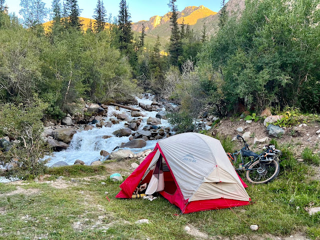
I slept reasonably well next to the gushing waterfall alongside gravel M-068. The cold rushing water kept things chilly and damp throughout the night, and there was ice on the fly when I got up. Last night before going to sleep I had treated my sunburn with Lucas Papaw Ointment. This morning I applied it to my chapped feet. I also spread chamois butter between my legs.
There had been nothing to lean my bike against, and it was a slow pack-up. All of my equipment was covered in brown dust. My tent was soaking wet and heavy, and yet I was able to roll it up and strap it to my front fork. The elastic straps required as much strength as my poor ravaged fingers could manage.
I had difficulty getting my Wahoo GPS unit started and I almost resorted to the back-up unit. I’d now ridden twice at night, and still needed to adjust my headlight beam which was aimed too high. I also hadn’t had a chance to check bolts and inspect things. Adjustments took time, and I kept pushing them back. That said, I religiously lubed my chain every morning before departing.
I started off in my bib, leg-warmers, rain pants, jersey, winter under-layer, merino wool under-layer, gilet, jacket, and long-finger gloves. I was in a gorgeous narrow canyon cut by the Malyi Naryn River. I was riding on crunchy gravel with towering valley walls to either side, and passed a cluster of yellow mullein flowers in a clearing.
Last night's decision had probably cost me and I regretted not riding to the yurt camp. Every miscalculation set me back, and there was no way to make up the time. That said, I’d been lucky with the weather, my stomach, and mechanicals. It was hard not to let other racers' positions get in my head. Today's goal would be checkpoint two at Kel Suu, which was on top of the next plateau. I would eat and resupply in Naryn, after which there would be a thirty-eight mile stretch of asphalt where I could cover some distance. At Kel Suu I'd be able to sleep in a yurt and get hot meals.
I passed Romain and Gautier (213 A&B France) bivvied on the side of the road and still asleep. I then crossed a bridge over the river. The narrow gorge was packed with boulders and spruce. I stopped to remove my rain pants and tried using my dynamo to recharge my phone on the descent. It only charged when I was riding fifteen miles an hour or faster.
After six miles I came to the yurt camp and then crossed a bridge to the other side of the river. It was 8 AM and I didn’t see Andrei or Dmitiri. M-068 here was also now known as Kokotaevev Sheraalу. I crossed a tributary, the Kalmak Ashuu River, and then came to the junction with M-078, which was also gravel. I next rode through the small village of Eki-Naryn, where I had heard there were yurt camps. I didn't see any services and kept pedaling.
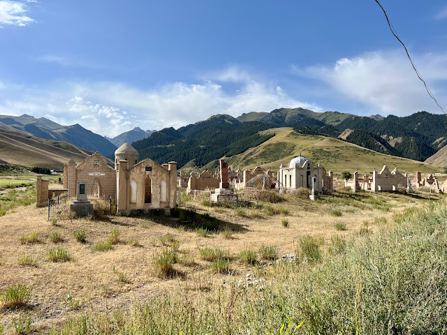
I passed a necropolis and was captivated by this elaborate city for the dead. Instead of headstones, small houses had been erected to memorialize the deceased. They had been created during the Soviet period, which had been prosperous for Kyrgyzstan. Before the Russians had arrived most Kyrgyz had lived a nomadic existence, and special monuments didn't exist. The tombs combined nomadic customs with Muslim architectural forms. Over time the mud-work mausoleums were slowly disintegrating. Everything within the walls was overgrown with weeds, as it wasn't Kyrgyz tradition to frequent the graves of the dead.
At 8:48 AM I descended a switchback and crossed the Naryn River at the confluence of the Malyi Naryn. The sun was strong and mixed with wispy clouds. I then began my approach into Tash-Bashat. I could see a cell phone tower ahead in the distance, and switched off my airplane mode. It was the first signal I'd had in two days. I uploaded stats to Strava, downloaded mail, and checked messages while I pedaled. The road took me through just a corner of the town.
I crossed over the Kayyndy River and then rode through a gate at Kulzha. I passed a roadside concrete ram monument and then crossed over the Burgan-Suu River. I was passing cultivated fields and once again seeing houses and structures. One of the rods had snapped on my underside downtube bottle cage, and it would need to be repaired. This had happened before on previous bikepacking tours, and I had taken to the practice of strapping the bottle to the downtube. In the meantime I was stowing an empty bottle in this cage.
I rode alongside the Naryn River and then through the village of Döbölüü. Asphalt pavement resumed at 9:40 AM. I rode through a welcome gate that encouraged travelers to enjoy their trip. At the top of the arch was a domed ring with three crisscrossing bars that resembled a tunduk. A tunduk is the opening found in the center of a yurt roof, and it is prominently featured on the Kyrgyz flag. I crossed the Chenkuenkursai River and rode through the village of Alış where I noticed stacks of dried cow patties in someone's front yard. M-068 here was known as Esenalieva Street. I then crossed the Alış River.
I stopped to admire three elaborate mausoleums standing alongside the road. The right tomb memorialized a local man whom had lived from 1900-1971. It featured Kyrgyz decorative patterns in relief, as well as images of a yurt and horses. There were stag reliefs above the entrance. I believe the center tomb memorialized his daughter, and her portrait was painted above the entrance. She had lived from 1918-1970. The left tomb featured two large paintings depicting cattle, stags, and wilderness with mountains and rivers. This person had lived from 1929-1973.
I was getting close to Naryn, and stopped at a magazin in Salkyn-Tor for a bottle of Sultan peach iced tea. I rode into Naryn on Moldoev Abdykadyr Street and was welcomed with a metal red and blue painted roadside Naryn sign. A concrete leopard was perched on a roadside bluff. I passed a mosque with minaret and golden dome. A little boy on a bike rode alongside me in the shoulder, and we cheered for one another. I noticed a house decorated with green-colored diamond patterns and then a blue-painted wooden slat fencing with scarlet-colored diamonds with white borders. I'd been able to charge my phone ten percent on the asphalt coming into Naryn.
Naryn, population 41,178, is situated along both banks of the Naryn River. The main road (highway ЭМ-11) had been an ancient branch of the Silk Road, and Naryn was established as a fortress on the caravan route running south to the Torugart Pass and China. Naryn's current economy is dominated by farming and animal husbandry, and it is the poorest region in the country.
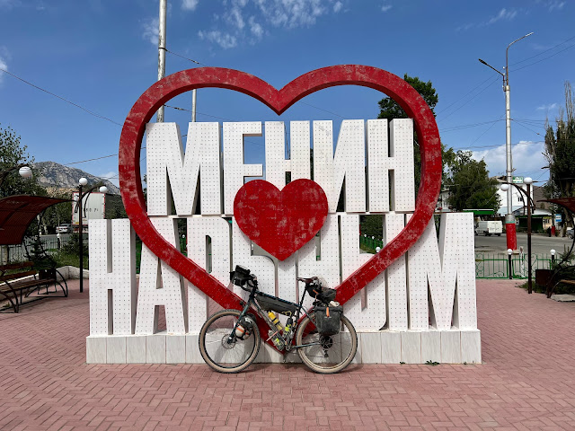
Naryn was the destination for segment three, and it had loomed large in my mind. I had expected it to be larger and was disappointed when I arrived. I had noted several hotels including the Grand Khan Tengri, and a visit to the Blue Mosque was on my itinerary. I arrived at a three-way junction where M-068 (Sheralieva Street) intersected with M-072 (Lenina Street) and ЭМ-11 (Sheralieva «Sovetskaya» street). As was my custom, I stopped at the large 'My Naryn' ❤️ sign. There were nearby shops and market stalls, and I googled restaurants. I rode over to Ali Kebap where another racer's bike was parked out front.
Inside I ran into Quentin who was seated at a table and halfway through his meal. He was on the phone with his wife. I sat down at his table and when given a menu, pointed to what was in front of Quentin. I plugged in my devices and went to the bathroom where I relieved myself and thoroughly cleaned my face, hands, arms, and crotch. I enjoyed french fries, kebab with rice, rice and onions, and a pizza with beef. I uploaded images to Instagram, and switched out my paper map and loaded the next course section on my Wahoo. Quentin had checked the standings and was currently in seventieth place. I was in position seventy-two. Fifteen racers had scratched, including Manu (cap 63) whom I had met last summer on the divide. He had crashed and broken several ribs. I removed my wool base layer, leg-warmers, and jacket.
After lunch I repaired my bottle cage with a zip tie and gorilla tape. Two friendly men from Bishkek stopped to help. They mentioned that they were also cyclists and offered additional zip ties from their car. I was running low on spare zip ties and was grateful. I asked whether there was a Globus or large supermarket in town, and there wasn't. So I rode back back to the market that I'd seen when I first arrived. There I purchased water, bread, cheese, canned fish, and more Snickers bars. I stopped at a street stall for a few bananas.
I couldn't locate the Blue Mosque on my phone and was pressed to continue forward. On my way out of town I ran into Veera who mentioned that Christian's derailleur had broken up on Arabel Plateau. Dylan's derailleur had also snapped, but he had brought an extra hanger. Veera had misplaced her sunglasses and was retracing her steps. My sunglasses were prescription, and I'd be hard-pressed if I lost them. Veera mentioned that she had bathed earlier in the river.
I passed several gas stations as I headed out of town on asphalt two-lane busy highway ЭМ-11. Naryn stood at 6737' elevation, and it was much warmer than up in the mountains. The sun was blazing, and I stripped down to my shorts and donned my arm protectors. It was going to be a sweltering afternoon. As I was climbing a hill, it occurred to me that I could put the broiling sun to use. I stopped and unfurled my damp tent, fly, and tarp to for a quick bake in the rays. I lathered sunscreen while I waited. My gear dried instantly and I continued up the hill.
I was following the Кара-Суу River (Black Water) upstream and, after a switchback, passed an old Soviet hammer and sickle monument. Cement jersey barriers were to my right and I could see an equestrian monument atop a hill in the distance. I then passed a stylish and colorful roadside structure that featured painted imagery of snow-capped mountains. A few miles later, while interested in another roadside equestrian monument, I missed the turn onto M-066 aka Naryn White Ice Street. It was under construction and the entrance was blocked with barriers. I had assumed that I would be staying on highway ЭМ-11. The first thirty-eight miles out of Naryn were supposed to be paved, and I had only ridden ten.
M-066 aka Naryn-Ak Muz Street was barely ridable. Ditches had been excavated for culverts and large piles of dirt filled the road. The occasional completed sections were short-lived and would abruptly end. The smoothest route was often on dirt tracks to the side of the construction area. Tall mountains with snow patches lay ahead to the south, along with dark clouds. I was hot and welcomed a cool shower. I finally caught up with Quentin and then passed him. I had climbed to 8585' elevation and then began descending. I passed an elaborate domed tomb on the side of the road. and then I crossed the Boroondu Suusu (Storm Water) River.
An asphalt surface returned just before the small village of Ak-Muz. I had ridden eight miles from the highway turn-off. There was a magazin at the junction of M-076 where I stopped and purchased two bottles of peach-flavored iced tea. Quentin caught up and we sat out front in the shade, around the corner from where our bikes were leaning. A group of curious young boys arrived, and began asking us questions. They swarmed all over our bikes and I didn't pay it much mind. It was 4pm when we left.
Ak-Muz would be the last service before CP2. Aside from the yurt camp at Kel Suu, it would be remote territory for the next several days until Baetov. It was still sunny and hot, and M-076 was washboard gravel and ridiculous to ride. I was pedaling on the dirt shoulder to the left of the road when a guy on horseback came galloping past me. I began noticing dirt paths running parallel to the road like arteries. Nobody could deal with the washboards. I followed Quentin's lead and left the highway. Motor vehicles were also choosing the alternate dirt tracks and were kicking up plumes of dust. I lifted my buff every time a vehicle passed. I was slowly climbing. It was gradual and I had a tail wind. All of these mountain passes had thermals. The wind assisted the climb, and then pushed against me on the descent.
I cruised down a hill and crossed a bridge over the At Bashe River. Quentin was sitting on the side of the road resting. On the other side of the road a little girl and her mother were sitting on a boulder waiting for local transport. The girl ran over and offered me some berries. They were tart and absolutely delicious. I was tired and needed a break. My left Achilles tendon was bothering me. Quentin left before I did. This was an nature area known as Bosogo. From here the course curved right and climbed past groves of spruce trees. I was now following a stream called the Kındı. I passed a yurt camp and went through a gate. It was 6:30 PM and the sun was descending as I headed south towards the pass. It was starting to get cold. I passed a painted concrete falcon, as my long shadow cast upon the crunchy gravel.
As I was slowly climbing I came to a wide pasture with power-lines running parallel to the road. Large steel poles were evenly spaced every few hundred feet to my left. Ahead in the distance I could see Quentin beginning the first switchback up towards the plateau. I had ridden my eighty mile quota and was still fifty miles from CP2. I was tired and figured it would be wise to camp at 9,320' rather than 12,000'. I stopped at a pole to lean my bike, and began setting up camp. I didn't want to sleep underneath the power lines and erected my tent a safe distance away. I hauled my camping gear and supplies over to where I was setting up. When I returned to my bike to turn off my tracker, I realized that it was missing. This was alarming. It had been attached to my saddle with a carabiner and I had been turning it off every night to save battery. I had coincidentally taken a photo of it earlier when I was drying out my tent. Had the washboards knocked it loose? Jono had mounted his tracker to his handlebars where he could always see it. This was my first time using one.
My location was no longer visible to friends, family, Nelson, or other racers. Would they think that I had crashed or that I was stranded? My followers could no longer track my standing or vicariously experience my adventure. But was I doing this race for them or for myself? Would the organizers make me drop out of the race without a tracker? Would I be able to get a replacement at CP2? I had a lot of questions and concerns. What on earth had happened to my tracker?
Oscar was making his way up the road and I asked him to tell the organizers at CP2 that my tracker was missing. Then Andrei rode by and I told him the same thing. He was able to send messages through his tracker and promised that he would contact Nelson from up on the plateau. He mentioned that he was having problems with his bottom bracket and had to go to an auto mechanic in Naryn.
I adjusted my headlight beam, lubed my chain, tightened loose bolts, and gave my bike an inspection before turning in. There were cows in the pasture and I wondered if I'd have visitors during the night. It was getting chilly and I ate bread and cheese in my tent. When I went out to brush my teeth I noticed racers' headlights coming up the hill in the distance.
 |
| Beautiful (but chilly) campsite adjacent to a waterfall |
 |
| The beautiful gradual descent into Naryn |
 |
| Romain and Gautier (213 A&B France) sleeping in |
 |
| Fantastic necropolis outside of Naryn |
 |
| Stacked manure for winter fuel |
 |
| Fantastic mausoleums outside of Naryn |
 |
| Fantastic mausoleum outside of Naryn |
 |
| Typical Kygyz house decoration |
 |
| Typical Kyrgyz wooden fencing |
 |
| Welcome to Naryn |
 |
| Lunch at Ali Kebap in Naryn |
 |
| Lunch at Ali Kebap in Naryn |
 |
| Drying out my wet gear in the hot sun |
 |
| My tracker before it went missing |
 |
| Roadside Soviet monument |
 |
| Roadside monument |
 |
| Roadside equestrian monument |
 |
| Choosing the dirt track instead of the gravel. This section had been marked as asphalt |
 |
| Roadside Falcon monument |
 |
| Map / Elevation Profile ⥢ prev -home- next ⥤ |


Comments
Post a Comment